In order to find the geographical coordinates, or, simply speaking, the position or location of a certain object, what we need is the latitude and longitude of that object. And, when we have both of them, we can easily mark out that specific position.
Latitudes are horizontal circular lines we use to measure north-south direction across globe & longitudes are vertical circular lines we use to measure east-west direction across globe.
Not to mention, both of them are imaginary lines plotted around the globe. Additionally, both of them represent the geographical coordinate system. Nevertheless, before going into a deep discussion, let me give you a brief review of the two in a tabular form. Let’s dive right in!
10 Differences Between Longitude and Latitude
| Latitude | Longitude | |
| 1. | Latitude refers to the geographical coordinate that determines the position of an object in the north-south of the equator. | Longitude refers to the imaginary geographical coordinate that determines the position of an object on the east-west of the prime meridian. |
| 2. | Latitudes are also known as Parallels. | Longitudes are also known as the Meridians. |
| 3. | The direction of latitudes is from east to west, therefore, horizontal lines. | The direction of longitudes is from north to south, therefore, vertical lines. |
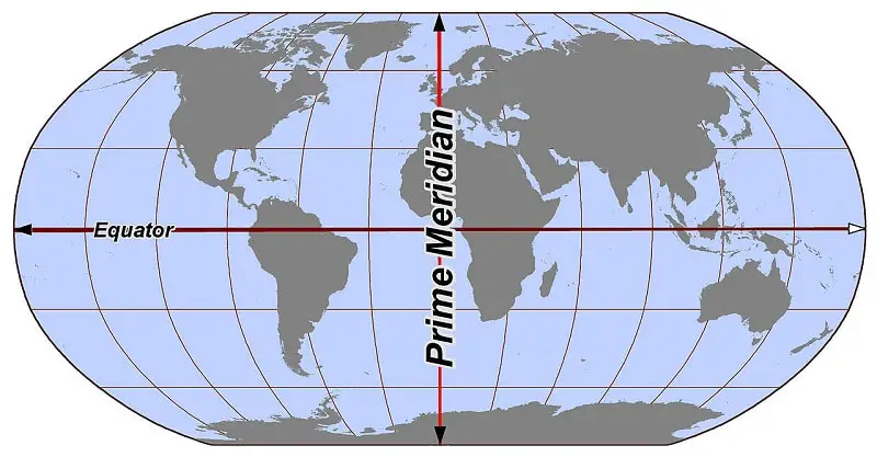
| 4. | The central reference point of the lines of latitude is the Equator. | The central reference point of the lines of longitude is the Prime Meridian. |
| 5. | Lines of latitude are parallel and equal in length. | Lines of longitude are not parallel and unequal in length. |
| 6. | There are 181 lines of latitude. | There are 360 lines of longitude. |
| 7. | Lines of latitude divides the earth into the northern and southern hemisphere. | Lines of longitude divides the earth into the eastern and western hemisphere. |
| 8. | The range of latitude is from 0 to 180 degrees. | The range of longitude is from 0 to 360 degrees. |
| 9. | The symbol of latitude is the Greek letter ɸ (phi). | The symbol of longitude is the Greek letter λ (lambda). |
| 10. | Lines of Latitude help to classify the different heat or temperature zones. | Lines of Longitude help to classify the different time zones. |
What is Latitude?
Latitude refers to the geographical coordinate that determines the position of an object north-south of the equator. Not to mention, these imaginary circular lines run from east to west.
Just like lines of longitudes, they are also measured in degrees. Additionally, latitudinal lines are always perpendicular to the longitudinal lines, and, vice-versa.
They are always parallel to each other and equal in length. In fact, just because all the lines of latitude are parallel to each other, we also call them parallels of latitude. Moreover, the symbol of latitude is the Greek letter ɸ (phi).
Highly Recommended: What are Lines of latitude? Definition & Diagrams
How many latitudes are there?
As you already know that all the parallels of latitude are usually measured in degrees. Speaking of degrees, by the same token, the very first circles of latitude start from the equator which is at 0 degrees.
One can also say that the central reference point of the lines of latitude is the Equator. Therefore, as a result, it virtually divides the world into the Northern and Southern hemispheres. Later, from the equator, these circles expand to the north and south poles of the earth.
Both the north pole and south pole are at 90 degrees with respect to the equator. So, when you count all of the lines of the latitude above and below the equator. What you get are 180 parallels.
And, when you add the equator i.e at 0 degrees, you get 181 degrees of latitude. To put it differently, (90 for the equator to the north pole) + (90 for the equator to the south pole) + (1 for the equator itself) is equal to 181 circles of latitudes.
Additionally, the distance between each degree of latitude is about 69 miles (110 kilometers).
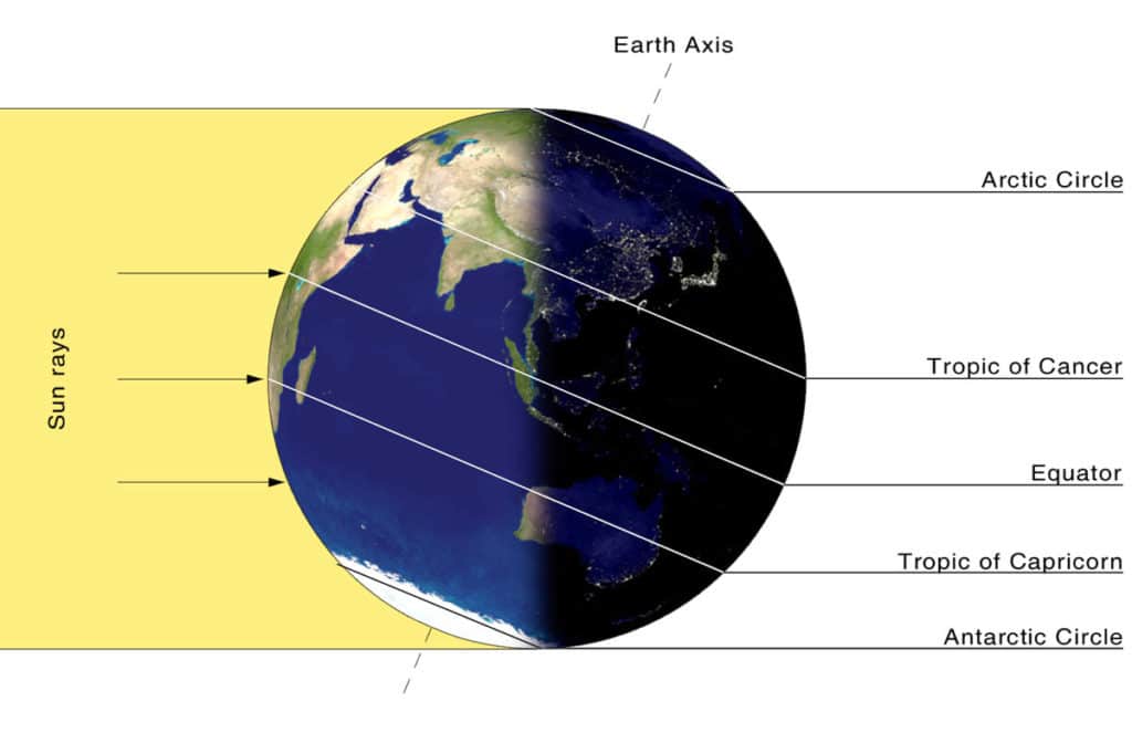
Most Important Lines of Latitude
Out of all the 181 lines of latitude, these are the most important ones!!!
- Arctic Circle
- Tropic of Cancer
- Equator
- Tropic of Capricorn
- Antarctic Circle
Applications of Lines of Latitude
If you think you can’t relate to the real-life applications of lines of latitude, well, here is your chance to think again.
- We use latitudes to specify different temperature zones.
- Both latitude and longitude are important to specify different locations around the globe, etc.
Editor’s Choice: Difference Between Equator and Prime Meridian (Tabular Form)
What is Longitude?
Longitude refers to the geographical coordinate that determines the position of the object of the east-west of the prime meridians. Not to mention, these imaginary circular lines run from north to south.
Just like lines of latitude, they are also measured in degrees. Additionally, longitudinal lines are always perpendicular to latitudinal lines, and, vice-versa. They are not parallel and unequal in length. Moreover, the symbol of longitude is the Greek letter λ (lambda).
Editor’s Choice: What are Lines of Longitude? Definition & Diagrams
How many longitudes are there?
Since there are 360 degrees in a circle or a sphere and longitudes are measured in degrees. As a result, in total, there are 360 longitudinal lines. Just because each of the lines of longitude is also one-half of the great circle, they are also called the meridians.
Speaking of meridians, unlike latitudes, there is no permanent central longitude. Therefore, as a result, in order to measure position and time, over a period of history, cartographers and geographers have designated different locations as the central longitudinal reference point.
Important Line of Longitude
In the current world scenario, the longitudinal line that runs through Greenwich, England, is considered the central longitudinal line. That’s why the Greenwich meridian line is known as the prime meridian.
Since the Greenwich Meridian is the prime meridian, it is assumed to be located at zero degrees longitude. Therefore, as a result, it virtually divides the world into the Eastern and western hemispheres.
If I talk in terms of the total longitudinal lines, there are 180 lines of longitude in the Eastern Hemisphere. On the other hand, there are 180 lines of longitude in the western hemisphere.
Applications of Lines of Longitude
If you think you can’t relate to the real-life applications of lines of longitude, well, here is your chance to think again.
- We use longitudes to specify different time zones.
- Both latitude and longitude are important to specify different locations around the globe, etc.
That’s it for this post. If you like this article, share it if you like, like it if you share it. You can also find us on Mix, Twitter, Pinterest, and Facebook. Hey man, If you have come this far, do give us feedback in the comment section. It would make my day. You can also make a donation. Your donations will help us to run our website and serve you BETTER. Cheers!!!
Nice
Nice post sir, keep posting dear
I want to know more about it